| The district was known as
Panchmahals because it was originally consisted of five
mahalas
(i.e. Palace)
The district consist of territories situated
on and around. The total area of the district is 5,13,819
Hectare It is divided in 11 Talukas.
The total Populatinon
of the district is 10,44,937 among which is male and 9,80,340
female from 1201
villages that is total population 20,25,277 According to
last census - 2001.
Monsoon is very tough in Panchmahal. The
district lies between 20.30 to 23.30 north latitude and 73.15
to 74.00 east longtitude.
Area in
Sq. Km |
No.
of Blocks |
No. of Inhabited
Village |
No. of Towns |
Populating Density
per Sq. Km |
5083.71
Sq. Km |
11 |
1,112 |
6 |
378 |
Summer starts from March to June in the district.
The temperature goes beyond 40 degree. During summer. December
January and February are the days of winter during these days
the temperature goes below 5 degree.
There were 10 Talukas and 1 Mahal before 2nd October 1997.
Godhara, Kalol, Halol, Jambugoda, Shehra, Lunavada, Dahod,
Jhalod, Santrampur, Limkheda, Devgadh Baria. there for district
has 11 Talukas at present.
The headquarter of the district is at Godhra. The district
is situated in the middle east part of Gujarat state &
in the north it is bounded by Bansvara & Dungarpur Rajsthan.
Uz Baroda, Dahod, Kheda & Sabarkatha.
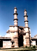
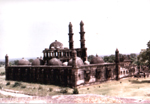
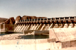
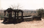
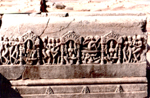
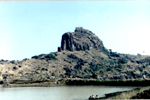
The important tourist places of the district are Kadana dem,
Mahi river, Pavagadh, Champaner, Kaleshvari, Jambughoda Tracking
roots, Malav, Lunavada, Chhota Kashi Aniad, Panam project.
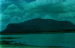
River system and Water Resource:
Average 800M.M.Rain.Most of the rivers in the district originates
from Malwa hills. These rivers are entirely dependent on monsoon
Following are the important rivers, Panam, Chikani Kun, Khan,
Kabhtri, Chibota, shri Vishvamitri, Hadap. Sant state before
the merger the seventh state,The sant state had zag villages,
which had been constitutated in the Satrampur taluka of the
district. It covered an area of 13,6,621 SqKm or (527.5 Miles)
When the Ruler died heirless. Today there are 152 village
after division of talukas.
The Lunavada State:
Before the merger,
the Lunavada State was a state it self 356
villages covering an area of 1004.92SqKm (388 Sq miles) except
the following 16 villages, all villages (340) before divided
taluka.
The Jambughoda State:
Before the merger Jambughoda was a jurisdictional
State and had 57villages covering an area of 370.37Sqkms or (143
Sq Miles). Kadana state situated to the north of the sant state
was absorved in the Sant state in 1943.
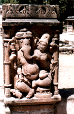
Life style and culture
:
Gujarati is the mother tongue of 96.18 %
of the population of the district. The main communities of the
district was Hindus, Muslim, Jains, Christians, Sikhas. Which are
Sub. devided in Shaivism, Vaishnavism, Swaminarayan, Vanvasi, Patidar,
Rajputs,,Kachchhi, Raval, Pateliya etc. All of them celebrated
their festivals and ather traditions. The Ras garba, Bhavai, Ramlila
Bhajan mandali are the speciality of the district. The main source
of income is small business and agriculture and cattle breeding
and dairy.
The Lok Mela :
The lok mela in each and every Taluka of
the district has its own imporantance. |
| |
| - |
| |
| - |
|
| |
|
| |
|
Kaleshwari
Choli
of Bhima
|
|
| - |
| |
| - |
|
| - |
|
 |